

Water & Climate
From the ninth to the fifteenth centuries, Angkor was one of the most advanced urban centers in the world. Some estimates suggest that the population numbered close to a million people, making greater Angkor by far the largest city in the world in this period. In this module, we explore the Khmer relationship with the environment.
Living with Water
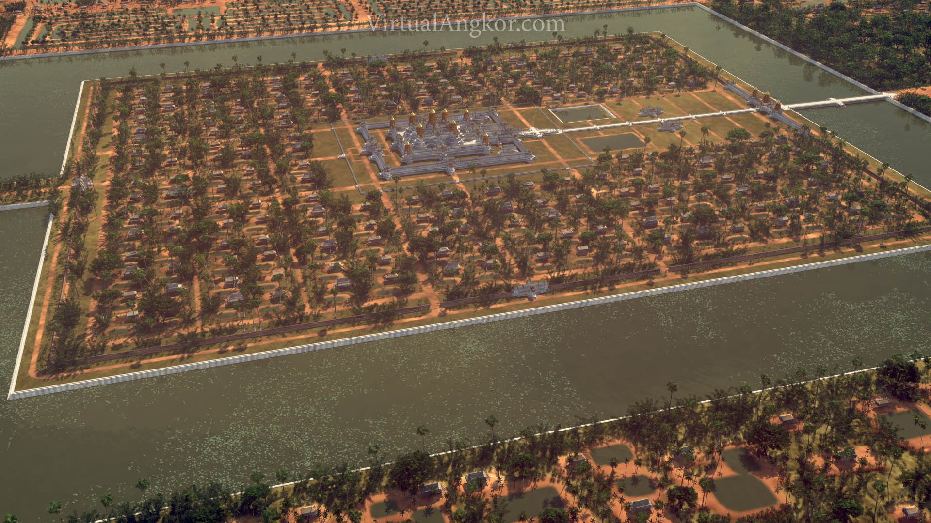
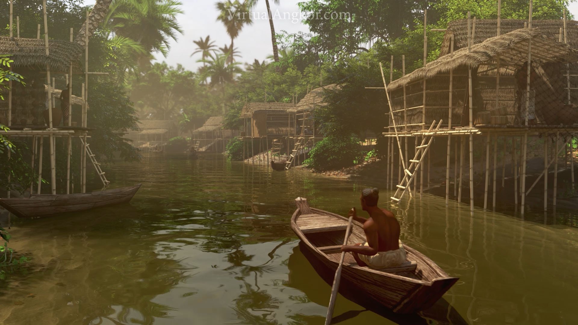
The Khmer people that inhabited Angkor had an intimate and complex relationship with water. As their empire grew, so did its thirst for water. The population of Angkor interacted with water on a day to day basis through a sprawling network that served in part to regulate floods and irrigate agriculture.
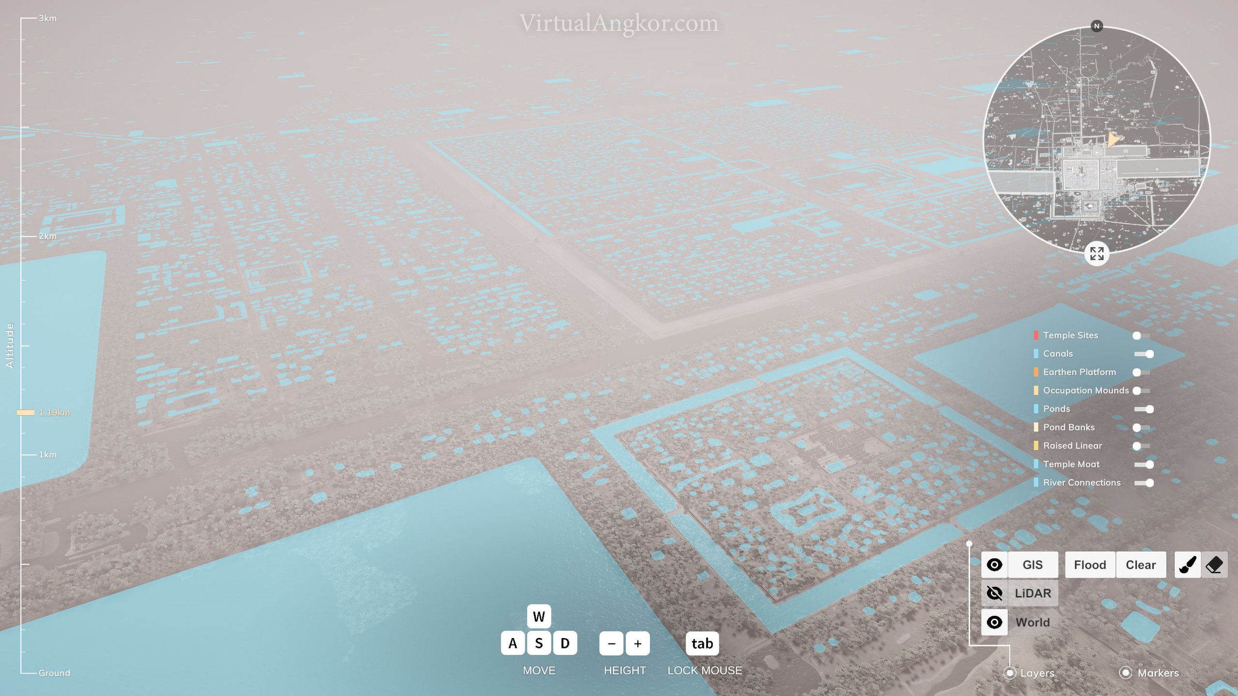
“The network of water management infrastructure that was developed in the heartland of the Khmer Empire during the classical Angkor Period (approximately ninth to fifteenth centuries AD) is one of the signal engineering achievements of the preindustrial world … The broader network consists of three major components: an upstream system of diversions, canals, and dams designed to alter the natural flow of water across the Angkor plain and channel water toward the central monumental zone; a central system of temple moats and vast reservoirs (known locally as baray) designed to store that water (Fig. 2); and a downstream system of canals radiating out from the center designed for the dispersal of stored water (Kummu 2009).” (Evans 2014, 2215)
“Sandstone blocks are the main construction materials used in the Angkor monuments in Cambodia. However, a thorough study of the quarries has not yet been carried out. We conducted a field investigation of sandstone quarries from the Angkor period at the southeastern foot of Mt. Kulen, which is approximately 35 km northeast of the Angkor monuments. As a result, we discovered more than 50 sandstone quarries. On the basis of the measurements of magnetic susceptibilities and thicknesses (step heights), we found that they were quarried at different times. These four quarrying areas were identified as the quarries D to G inferred by Uchida et al. (2007). In addition we investigated a canal that was identified on satellite images, connecting quarry sites at the foot of Mt. Kulen to the Angkor monuments. The field investigation suggests a high probability that the canal was used for the transportation of sandstone blocks from Mt. Kulen.” (Uchida and Shimoda 2013, 1158)
Questions
How was water channeled and controlled in greater Angkor?
Where are the houses? Why do you think they have been built here? What does this tell you about Khmer understandings of their environment?
Does this relationship between water and urban design remind you of any other cities?
What do Uchida and Shimoda set out to find? Why do transportation routes matter and how did Angkor’s system of canals enable the creation of the great monuments of the city?
The Hydraulic City
In the 1950s, the French archaeologist Bernard-Philippe Groslier introduced what became known as the “hydraulic city” hypothesis. This argued that Angkor was built on a vast water management system of canals, reservoirs and tanks that provided a constant supply of water for crops. Groslier suggested that the Khmers had established an agricultural system that was capable of sustaining a massive population who in turn served as the labor force that constructed the grand temples of Angkor. Since its publication, a fierce debate has erupted over the validity of the “hydraulic city” hypothesis. Groslier’s critics argued that Angkor’s canals and reservoirs were not part of an elaborate irrigation system but were designed largely for religious purposes. The debate continues but advanced mapping and remote sensing technology has confirmed at least part of Groslier’s thesis by showing the existence of a sophisticated water management system at Angkor.
“In the Khmer Empire, water played an essential part in the ‘theatre of state’, as well as in the functioning of the urban settlement and its vast components. The kings of Angkor, from Yaśovarman I onwards, made grand statements of territorial control. Often, these were combined with the establishment of inscriptions and the installation of images of deities on the temple islands created in the baray, known as mebon. The kings' vision was that these statements created certitude (in the minds of the populace) about the king's control over sovereign territories, and established power within central Angkor. Elaborate ceremonies presided over by the kings and their advisers would have played a part in these events. The hydraulic systems, linked with the baray, created not only a water control mechanism but also a spiritual hub between incoming and outgoing water. This gathering together of the powerful forces of nature and the heavens through meritorious public works seems to have been a clear objective of the kings of the Khmer Empire.” (Feneley, Penny, and Fletcher 2016, 290)

Map of the greater Angkor area, cited in Feneley, Penny, and Fletcher.
Questions
Where do we find water and water features in the city? How does this compare with the city in which you live?
Angkor has been described as a “hydraulic city”. What does this mean? How does this change our understanding of the city?
How do the Khmer kings use water as part of the “theatre of state”?
Look at the distribution of water across the city of Angkor and its immediate surroundings. What does this tell you about how the Khmers interacted with water? What role did water play in the expansion of the Khmer Empire?
Climate Vulnerability
In the fourteenth century, the Khmer empire began a process of slow decline that continued until its final collapse in the fifteenth century. Population in greater Angkor declined rapidly although the city was never fully abandoned. The Virtual Angkor project simulates greater Angkor at its peak around 1300 so it doesn’t show this long process of decline but some of the factors that underpinned this later collapse are present in our model.
Scholars once thought that an external invasion had resulted in Angkor’s sudden collapse and abandonment. Now the scholarly consensus is that a range of different factors came together to initiate a process of decline rather than a moment of sudden collapse. While the precise mix of factors continues to be debated, recent archaeological and climatic research suggests that variations in climate, particularly long droughts combined with intense monsoons, were a significant contributing factor. A change in the weather systems that regulated monsoonal rains resulted in a severe drought that dried up the barays (reservoirs) around Angkor and put intense pressure on the primarily agricultural economy. For much of its existence, Angkor depended heavily on monsoonal rains and the use of water captured during the monsoon season and stored in barays to irrigate crops. To alleviate the droughts brought on by this change in climate, Khmer engineers undertook large-scale modifications of their existing water management system and embarked on an ambitious water diversion project. This proved, however, a costly mistake as they were eventually caught unprepared by unusually intense monsoon rains that overwhelmed the water management infrastructure and caused severe erosion and flooding across Angkor.
“The “hydraulic city” of Angkor, the capitol of the Khmer Empire in Cambodia, experienced decades-long drought interspersed with intense monsoons in the fourteenth and fifteenth centuries that, in combination with other factors, contributed to its eventual demise. The climatic evidence comes from a seven-and-a-half century robust hydroclimate reconstruction from tropical southern Vietnamese tree rings. The Angkor droughts were of a duration and severity that would have impacted the sprawling city’s water supply and agricultural productivity, while high-magnitude monsoon years damaged its water control infrastructure. Hydroclimate variability for this region is strongly and inversely correlated with tropical Pacific sea surface temperature, indicating that a warm Pacific and El Niño events induce drought at interannual and interdecadal time scales, and that low-frequency variations of tropical Pacific climate can exert significant influence over Southeast Asian climate and society.” (Buckley et al. 2010, 6748)
“Complex infrastructural networks provide critical services to cities but can be vulnerable to external stresses, including climatic variability. This vulnerability has also challenged past urban settlements, but its role in cases of historic urban demise has not been precisely documented. We transform archeological data from the medieval Cambodian city of Angkor into a numerical model that allows us to quantify topological damage to critical urban infrastructure resulting from climatic variability. Our model reveals unstable behavior in which extensive and cascading damage to infrastructure occurs in response to flooding within Angkor's urban water management system. The likelihood and extent of the cascading failure abruptly grow with the magnitude of flooding relative to normal flows in the system. Our results support the hypothesis that systemic infrastructural vulnerability, coupled with abrupt climatic variation, contributed to the demise of the city. The factors behind Angkor's demise are analogous to challenges faced by modern urban communities struggling with complex critical infrastructure.” (Penny et al. 2018, 1)
Questions
How did the climate shift in this period? How did Khmer engineers try to deal with climate variability?
As communities across the world face new threats brought about by climate change, what lessons can we draw from the role played by climate variation in the collapse of the Khmer Empire?
How did changes in climate impact the massive infrastructure system at Angkor? Does this remind you of anything today? How fragile was Angkor’s highly sophisticated infrastructure?
Water and Climate Image Gallery


Further Reading
Buckley, Brendan M., Kevin J. Anchukaitis, Daniel Penny, Roland Fletcher, Edward R. Cook, Masaki Sano, Le Canh Nam, Aroonrut Wichienkeeo, Ton That Minh and Truong Mai Hong, “Climate as a Contributing Factor in the Demise of Angkor, Cambodia”. Proceedings of the National Academy of Sciences 107 (15): 6748-6752.
Evans, Damian. “Hydraulic Engineering at Angkor.” In Encyclopaedia of the History of Science, Technology, and Medicine in Non-Western Cultures (2014): 2215-2219.
Feneley, Marnie, Dan Penny, Roland Fletcher, “Claiming the Hydraulic Network of Angkor with Viṣṇu: A multidisciplinary approach including the analysis of archaeological remains, digital modelling and radiocarbon dating: With evidence for a 12th century renovation of the West Mebon.” Journal of Archaeological Science: Reports, 9 (2016): 275-292.
Groslier, B.P. “The Angkorian Hydraulic City: Exploitation or Over-Exploitation of the Soil?” Translated by Terry Lustig and Cristophe Pottier, Bulletin de l'École Française d'Extrême Orient 66 (1979): 161-202.
Penny, Dan, Cameron Zachreson, Roland Fletcher, David Lau, Joseph T Lizier, Nicholas Fischer, Damian Evans, Christophe Pottier, Mikhail Prokopenko. “The Demise of Angkor: Systemic Vulnerability of Urban Infrastructure to Climatic Variations.” Sciences Advances 17 (2018).
Uchida, Etsuo and Ichita Shimoda. “Quarries and Transportation Routes of Angkor Monument Sandstone Blocks.” Journal of Archaeological Science 40, no. 2 (2013): 1158-1164.