
Technology
In the decade since it commenced, the Virtual Angkor project has evolved organically to encompass new technologies and approaches in an effort to present a comprehensive reconstruction of the city and its inhabitants.
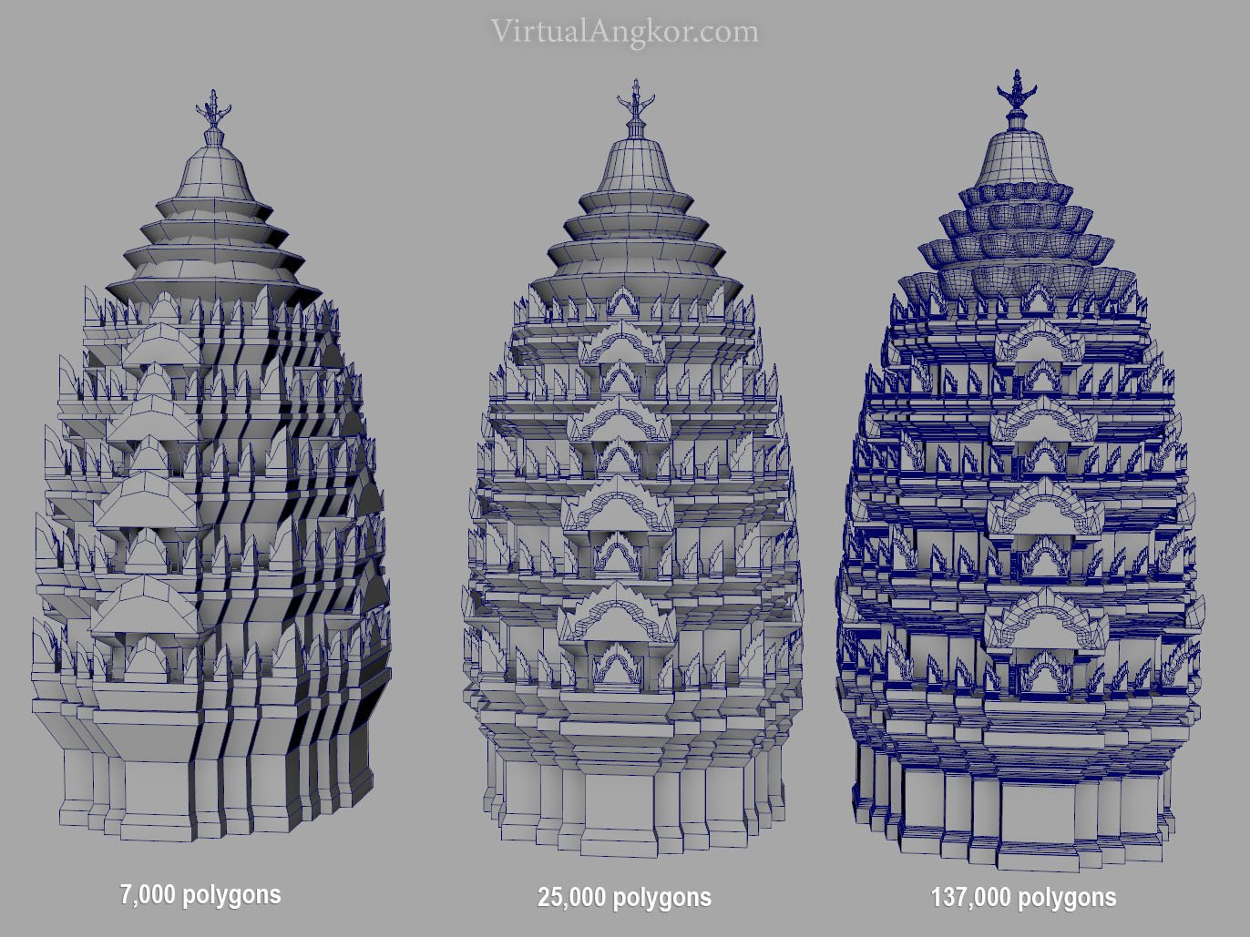
What does it mean to ‘model’ a historical city? For many digital heritage projects, the starting point is an obvious one: modeling architecture. The first model we made was not a reconstruction of an archaeological site but an animated character. It was one that featured prominently in Angkorian art and iconography, but it was neither a person, a god nor a mythological being. Instead it was an elephant. In the years after the completion of the first elephant, we modeled and remodeled the 3D anatomy of the people of Angkor, their ornaments, their attire, the objects that they carried, and the vehicles that carried them.
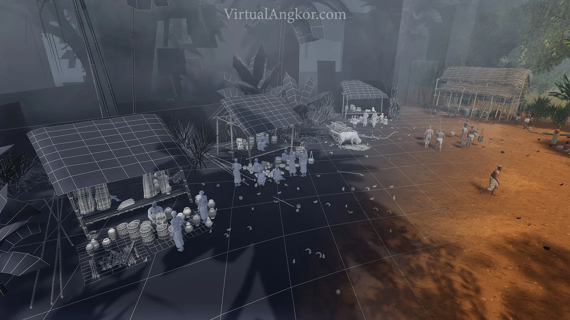
As we crafted more characters, it became necessary to draw in objects scattered beyond Angkor to situate them in the virtual world. There is a remarkable collection of Angkorian bronze statuary and status items maintained in museums and galleries around the world. Once scanned, these artefacts were digitally repatriated from museum displays and archives and then merged with the array of Angkorian 3D models we had already assembled. With these characters in hand, we started to approach modeling the rest of Angkor; the roads, the canals, the rice fields and the wooden dwellings that once comprised the vast city of Angkor.
At Angkor, the ruins of temples have long served as focal points of scholarly interest and investigation. We were interested however in the spaces surrounding the temples, both inside the extensive laterite walls and outside the temple moats, where many of Angkor’s 750,000 inhabitants would have lived their lives. To see the living city, however we needed help from a different data set beyond the surviving structures. We relied especially on extensive archaeological mapping conducted by the University of Sydney’s Greater Angkor Project and the EFEO (Evans, Pottier et al. 2007).
In 2014, we transitioned away from constructing 3D scenes built to render single images and animated sequences and began importing all of our models into Unity. It was around this time that the scope of the project broadened considerably as we were able to instill the animated figures with dynamic behaviors. The result has been to create an expansive virtual environment. What is clear, however, is that the process of modeling Angkor in virtual reality has no definitive end. For more details see the article below:
Adam Clulow and Tom Chandler, “Modeling Virtual Angkor: An Evolutionary Approach to a Single Urban Space,” IEEE Computer Graphics & Applications, Volume 40, Issue 4 (2020), 9-16

The Virtual Angkor Project
The Virtual Angkor project aims to recreate the sprawling Cambodian metropolis of Angkor at the height of the Khmer empire’s power and influence in the twelfth century. For approximately 500 years from the ninth to the fifteenth centuries, the Khmer empire dominated the politics and economy of Southeast Asia. Centered on modern day Cambodia, it extended its influence across a vast swath of territory, encompassing most of present-day Thailand and the southern provinces of Laos and Vietnam. At its peak in the twelfth century, the city of Angkor, which had an estimated 750,000 inhabitants dispersed over an interconnected, hydraulic landscape, was “the largest settlement complex of the preindustrial world.” (Evans, Fletcher et al. 2013)
Virtual Angkor is a comprehensive, interactive, visual representation of life in the premodern Cambodian city of Angkor. It consists of three distinct applications, all assembled in Unity. These draw upon recent archaeological research including LiDAR surveys and geospatial repositories.

Interactive, navigable virtual map
The second application is an interactive, navigable virtual map of Greater Angkor that extends over almost 3500 square kilometers. This multilayered visualization incorporates LiDAR data, digital elevation (DEM) files, and GIS mapping layers.
We effectively ‘peeled off’ layers from this geospatial archive of cultural and natural features in the Angkor area – ponds, canals, occupation mounds, temple sites and rice fields – and translated them into bitmaps, with each map informing the distribution of 3D models above it.
The key data source for our virtual map of Angkor was a geospatial repository maintained by the University of Sydney and the EFEO. This is a comprehensive resource, resolving features from the landscape scale down to the level of individual households and artefacts in the archaeological record. It aggregates a century and a half of historic maps and the results of various archaeological survey and mapping campaigns since the 1990s.

Simulation of 24 hours in Angkor Wat
The first application is a simulation of a 24-hour cycle at Angkor Wat that aims to visualize the complex’s daily operation almost a millennium ago. Current archaeological estimates suggest that at its peak, the Angkor Wat complex, was serviced by a workforce of over 20,000 that were in turn supported by a population of up to 125,000 people.
Whereas historians typically model events over years or centuries, the time frame for our simulation, – 24 hours or literally one day in the life of the complex – is both more compressed and more familiar. It features a large population of autonomous ‘agents’, that is our original animated characters, following path finding (A*) algorithms.
We divided the agents into four broad categories; visiting elites and their retainers, residents, commuting workers, and suppliers. All agents are guided by broadly similar rules, though each agent category is given a different agenda in navigating the space of the city.

Virtual reality experience
The third application is a virtual reality experience of Angkor. Here we have adapted the cartography of the virtual map around the VR viewer. Once inside the VR headset, you can walk through the map, with the city stretching out roughly at waist level. Leaning down near to the landscape prompts a peal of location-based soundscapes, all based on field recordings, emanating from the temples, roads and fields. Mixed in among these sound files are the recordings of reconstructed Angkorian instruments that have been created by ethnomusicologist Patrick Kersale based on evidence in the bas reliefs of instruments that have long since vanished from Cambodia, and indeed wider Southeast Asia.
The ‘x-ray’ aesthetic of the opening map mimics the way that LiDAR scans the landscape for hidden features, but our reconstruction process effectively reverses LiDAR technology. The 3D models that are visible on the map denote the virtual reconstructions of Angkor that we have extrapolated upon, or assembled ‘on top’ of the LiDAR data. The result is a visualization of living city of Angkor growing out of its archaeological imprint. Using a controller, the VR user can select animated markers which transport them to scenes of daily life at ground level.